The Bab el-Mandab Strait
Context:
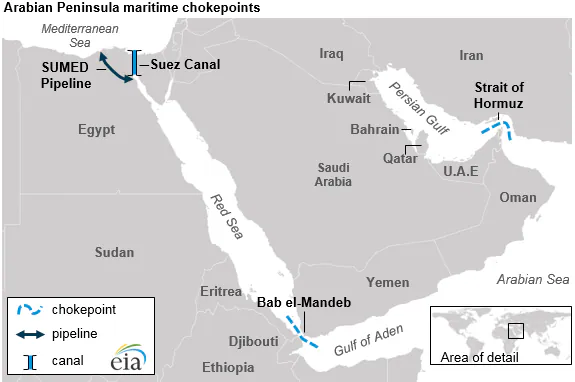
The Bab el-Mandab Strait, historically known as the “Gate of Tears” (Bab al-Mandab in Arabic), has once again become the focal point of global geopolitical tension. As a narrow maritime chokepoint, it acts as the southern sentry to the Red Sea, and any disruption here sends immediate shockwaves through the global energy and commodity markets.
Geography and Strategic Location
The strait is a narrow passage that separates the African continent from the Arabian Peninsula. Its geography makes it one of the most easily blockaded maritime routes in the world.
- Flanking Regions: It is bordered by Djibouti and Eritrea to the southwest (Horn of Africa) and Yemen to the northeast (Arabian Peninsula).
- Connecting Waters: It serves as the critical link between the Red Sea and the Gulf of Aden, which leads into the broader Arabian Sea and Indian Ocean.
- The Divide: The strait is split into two channels by Perim Island (also known as Mayyun). The western channel is the deeper, primary route used by large commercial vessels.
Why It Is a “Global Chokepoint”
A “chokepoint” is a narrow geographical feature that, if closed or threatened, can halt global trade. The Bab el-Mandab is arguably the most sensitive after the Strait of Hormuz.
- The Suez Link: It is the mandatory gateway for any ship traveling from the Indian Ocean to Europe via the Suez Canal.
- Energy Lifeline: Approximately 10% to 12% of global seaborne oil and millions of barrels of crude pass through this 29-km wide gap daily.
- LNG Passage: Over 30 million tonnes of Liquefied Natural Gas (LNG) pass through the strait annually, making it vital for European heating and industrial needs.
The Impact of Closure: The “Cape Route”
When the Bab el-Mandab becomes unsafe due to missile attacks or piracy, shipping companies are forced to take the “long way around” Africa.
- Alternative: Ships must sail around the Cape of Good Hope (South Africa).
- The Cost of Delay: This diversion adds roughly 4,000 to 6,000 nautical miles to a journey between Asia and Europe.
- Time Factor: It increases travel time by 14 to 20 days, leading to higher fuel costs, increased insurance premiums, and global supply chain delays.
[Image comparing the shipping route through the Suez Canal vs the route around the Cape of Good Hope]
Origin of the Name: “Gate of Tears”
The name Bab el-Mandab carries a grim historical weight.
- Geological Legend: Some believe it refers to the massive loss of life during an ancient earthquake that tore Africa and Asia apart, creating the strait.
- Navigational Danger: Others attribute it to the “tears” of sailors who perished navigating its narrow, rocky, and treacherous currents, which were historically difficult for sailing vessels to master.
Examination Focused MCQs
Q1. The Bab el-Mandab Strait connects which of the following water bodies?
A) Persian Gulf and Gulf of Oman
B) Red Sea and Gulf of Aden
C) Mediterranean Sea and Red Sea
D) Black Sea and Sea of Marmara
Q2. Which island strategically divides the Bab el-Mandab Strait into two channels?
A) Socotra Island
B) Perim Island
) Lakshadweep Island
D) Zanzibar Island
Q3. If the Bab el-Mandab Strait is closed, ships traveling from the Indian Ocean to Europe must divert around which geographical feature?
A) Cape Horn
B) Cape of Good Hope
C) Strait of Gibraltar
D) Panama Canal
Q4. Consider the following statements regarding the Bab el-Mandab Strait:
- It is bordered by Yemen to the northeast and Djibouti/Eritrea to the southwest.
- It is wider than the Strait of Malacca, measuring over 500 km at its narrowest point.
Which of the statements given above is/are correct?
A) 1 only B) 2 only C) Both 1 and 2 D) Neither 1 nor 2
Q5. Approximately what percentage of global seaborne oil passes through the Bab el-Mandab Strait?
A) 2% to 3%
B) 10% to 12%
C) 40% to 50%
D) 75% to 80%